Effective September 1, 2024, patrol boundaries for the Zionsville Police Department will be expanded. Listed below are the boundaries for our new patrol area.
NORTH: The new northern patrol boundary is CR 300 South and includes Brookhaven to the county line.
SOUTH: The new southern boundary is the Boone/Marion County line.
EAST: The new eastern boundary is the Boone/Hamilton County line.
WEST: The western boundary is CR 800 East from CR 300 South to Oak Street, then west to I-65.
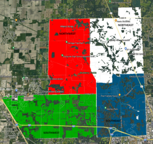
Our patrol area will be divided into four districts with the following boundaries:
NORTHWEST DISTRICT
- Northern boundary: CR 300 South
- Southern boundary: Oak Street
- Eastern boundary: Ford Rd. / Pleasant View Rd. (CR 975 East)
- Western boundary: CR 800 East
NORTHEAST DISTRICT
- Northern boundary: CR 300 S. plus Brookhaven to county line
- Southern boundary: Bloor – Mulberry – Turkey Foot – Temple – Willow – Templin
- Eastern boundary: Hamilton County line
- Western boundary: Ford Road / Pleasant View Road (CR 975 East)
SOUTHWEST DISTRICT
- Northern boundary: Oak Street / Whitestown Parkway
- Southern boundary: Marion County line (96th Street)
- Eastern boundary: Ford Road
- Western boundary: I-65
SOUTHEAST DISTRICT
- Northern boundary: Bloor – Mulberry – Turkey Foot – Temple – Willow – Templin
- Southern boundary: Marion County line (96th Street)
- Eastern boundary: Hamilton County line
- Western boundary: Ford Road
Our new patrol districts are displayed on the map below.
The Zionsville Police Department maintains a close relationship with the Boone County Sheriff’s Office.